Researchers collaborate to reveal new mechanisms of glacier melting
2024-10-31
The ongoing rise in sea levels poses substantial social and economic challenges for coastal regions worldwide. Currently, the Greenland Ice Sheet is the largest single contributor to the rise of the global mean sea level over the past fifty years. If it were to melt completely, it could lead to a global sea level increase of approximately seven meters. Despite decades of research on the melting mechanisms of the Greenland Ice Sheet, the critical scientific question of how meltwater flows inside the ice sheet remains unresolved.

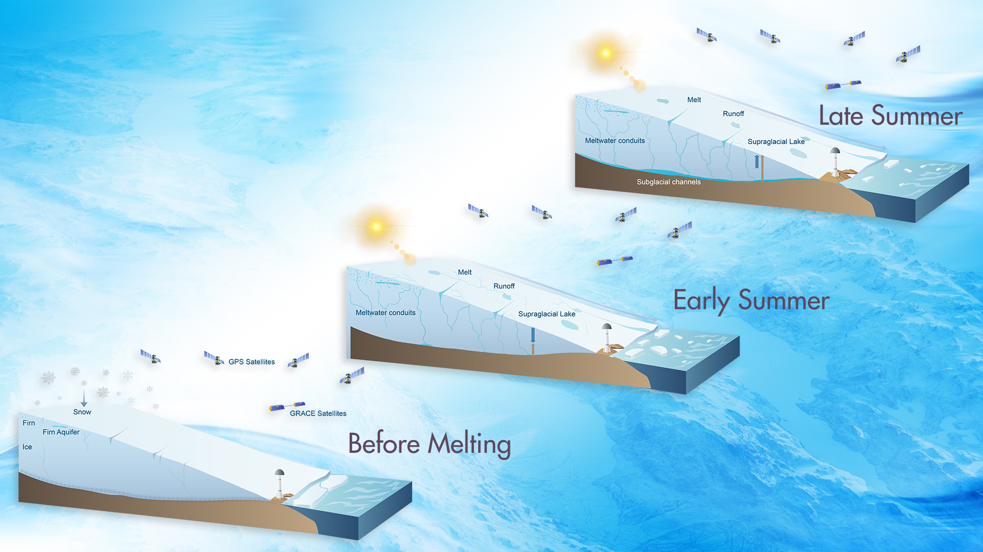
A research team led by Associate Professor Jiangjun Ran from the Department of Earth and Space Sciences at the Southern University of Science and Technology (SUSTech), in collaboration with international partners, has made significant progress in studying the mechanisms of glacier melting. They utilized the global satellite navigation system to reveal, for the first time, the evolution of meltwater inside and beneath the Greenland Ice Sheet (Figure 1).
The work, titled “Vertical Bedrock Shifts Reveal Summer Water Storage in Greenland Ice Sheet”, has been published in Nature.

Figure 1. Evolution of water storage and associated bedrock displacements within the GrIS at different stages of the melt season
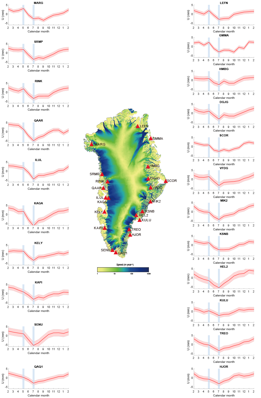
While remote sensing satellites and ground-based meteorological stations can effectively monitor changes in the ice sheet surface, they cannot shed light on the water evolution inside the ice sheet. After six years of dedicated research, Jiangjun Ran’s team and collaborators have revealed the retention time and spatial distribution of meltwater inside and at the bottom of the ice sheet (Figure 2) for the first time. This finding challenges the reliability of current regional climate models utilized to predict global sea level rise, reshapes our understanding of glacier dynamics, and will have a profound impact on predicting the evolution of ice sheets in future climates.

Figure 2. The mean annual cycles of residual vertical displacements at GNET sites
Furthermore, the amount of meltwater temporarily buffered inside the ice sheet is vast. It causes noticeable subsidence of bedrock at a maximum of approximately 5 mm close to the GNSS station, which is a challenge to establishing and maintaining a millimeter-level global vertical reference system.
Associate Professor Jiangjun Ran is both a co-first and corresponding author of this study, alongside Associate Professor Pavel Ditmar from Delft University of Technology (TU Delft) as a co-first author. The paper’s co-authors include Professor Michiel R. van den Broeke from Utrecht University, Professor Lin Liu from the Chinese University of Hong Kong, Professor Roland Klees from TU Delft, Professor Shfaqat Abbas Khan from the Technical University of Denmark, Professor Twila Moon from the University of Colorado, Professor Jiancheng Li from Central South University/Wuhan University, Professors Michael Bevis and C.K. Shum from Ohio State University, Professor Min Zhong from Sun Yat-sen University, Professor Xavier Fettweis and Dr. Brice Noël from the University of Liege, Professor Junguo Liu from North China University of Water Resources and Electric Power, Professor Jianli Chen from Hong Kong Polytechnic University, Professor Liming Jiang from the Institute of Precision Measurement Science and Technology Innovation of the Chinese Academy of Sciences, and Professor Tonie van Dam from the University of Utah. The Department of Earth and Space Sciences at SUSTech is the primary institution for this work.
Paper link: https://www.nature.com/articles/s41586-024-08096-3


